02 September 2014

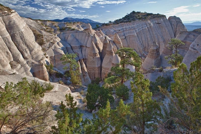
Kasha-Katuwe Tent Rocks National Monument, New Mexico

Kasha-Katuwe Tent Rocks National Monument, New Mexico

The Kasha-Katuwe or else they are called "Rock-Tents" or "Tent rocks" located 60 km southwest of Santa Fe, a city in the state of New Mexico near near Cochiti, USA, is a Bureau of Land Management (BLM) managed site, on the height of 1737-1951 m (5700-6400 feet) above sea level. Looking at them from the side, once you know where it came from such a title. Name Rocks Tents appeared because of its unusual appearance of rocks - they really look like a tent city. Cone-shaped tent of formation - the result of the vigorous activity of volcanic eruptions about 7.6 million years ago, under the influence of which formed the rocks of pumice, ash and residues of volcanic tuff. For many years, these rocks acted erosion, as well as wind and water. They carved in the rocks canyons, crevices, deep and picturesque gorges, polished rock, making a beautiful smooth rocks framing semicircles.
Kasha-Katuwe Tent Rocks National Monument, New Mexico


Although Tent rocks look very similar in shape, but they are very different in height - and vary in height from a few feet to 90 feet. Volcanic precipitation accumulated over the years as a result of volcanic rocks and, therefore, consist of piled up on each other's beds, they are gray with splashes of pink and beige. Perhaps that is why Kasha-Katuwe gets its name from the language that Puebloan keresan translates as "white cliffs". Place Kasha-Katuwe very chosen by tourists, and it's not enough, here it is, what to see and admire. All who have visited here, note that the picture looks interesting monument. But when you find yourself on the ground, will be even more surprised to live Kasha-Katuwe more beautiful. At the top - simply unbeatable scenery. [First Image credit Bureau of Land Management]

The Kasha-Katuwe or else they are called "Rock-Tents" or "Tent rocks" located 60 km southwest of Santa Fe, a city in the state of New Mexico near near Cochiti, USA, is a Bureau of Land Management (BLM) managed site

Kasha-Katuwe was added to the national monuments by President Bill Clinton in January 2001, the territory of a national monument laid guided trail length of 1.9 km. It is laid in such a way to allow tourists to enjoy the views of the rocks, as the lowest point and the highest. Getting around the monument is permitted only during daylight hours, and prevented from entering the car and take the dogs with them. Entrance to the National Monument is not expensive - $ 5, and for groups are available even discounts.

The Kasha-Katuwe or else they are called "Rock-Tents" or "Tent rocks" located 60 km southwest of Santa Fe, a city in the state of New Mexico near near Cochiti, USA, is a Bureau of Land Management (BLM) managed site
Image credit Jessica Colomb

The Kasha-Katuwe or else they are called "Rock-Tents" or "Tent rocks" located 60 km southwest of Santa Fe, a city in the state of New Mexico near near Cochiti, USA, is a Bureau of Land Management (BLM) managed site

The Kasha-Katuwe or else they are called "Rock-Tents" or "Tent rocks" located 60 km southwest of Santa Fe, a city in the state of New Mexico near near Cochiti, USA, is a Bureau of Land Management (BLM) managed site
Image credit Kevin Russ

The Kasha-Katuwe or else they are called "Rock-Tents" or "Tent rocks" located 60 km southwest of Santa Fe, a city in the state of New Mexico near near Cochiti, USA, is a Bureau of Land Management (BLM) managed site
Image credit Colin

The Kasha-Katuwe or else they are called "Rock-Tents" or "Tent rocks" located 60 km southwest of Santa Fe, a city in the state of New Mexico near near Cochiti, USA, is a Bureau of Land Management (BLM) managed site

The Kasha-Katuwe or else they are called "Rock-Tents" or "Tent rocks" located 60 km southwest of Santa Fe, a city in the state of New Mexico near near Cochiti, USA, is a Bureau of Land Management (BLM) managed site

The Kasha-Katuwe or else they are called "Rock-Tents" or "Tent rocks" located 60 km southwest of Santa Fe, a city in the state of New Mexico near near Cochiti, USA, is a Bureau of Land Management (BLM) managed site

The Kasha-Katuwe or else they are called "Rock-Tents" or "Tent rocks" located 60 km southwest of Santa Fe, a city in the state of New Mexico near near Cochiti, USA, is a Bureau of Land Management (BLM) managed site

The Kasha-Katuwe or else they are called "Rock-Tents" or "Tent rocks" located 60 km southwest of Santa Fe, a city in the state of New Mexico near near Cochiti, USA, is a Bureau of Land Management (BLM) managed site

Teufelsbrücke | The Devil's Bridge in Switzerland

Teufelsbrücke | The Devil's Bridge in Switzerland

Teufelsbrucke also known as Devil's Bridge - The name of the three bridges across the river Rёys or Ruess in the Alps Switzerland, near the village of Andermatt, 12 km north of the Pass of St. Gotthard . Wooden bridge in Andermatt existed from 1230 to 1707 . The first stone bridge spanned the gorge Rёys in 1595 . It is named for an old local legend regarding its construction by the Devil, one of many old European Devil's Bridges with similar creation myths. In memory of the legend on a rock near the Devil's Bridge red paint were painted devil and goat. These images are still preserved. Devil's Bridge was a narrow stone arch length of about 25 meters, thrown over the gorge at a height of 22 - 23 meters above the roaring rapid stream.
Teufelsbrucke also known as Devil's Bridge - The name of the three bridges across the river Rёys in Switzerland, near the village of Andermatt , in the Alps , 12 km north of the Pass of St. Gotthard . Wooden bridge in Andermatt existed from 1230 to 1707 .
In 1799 during the Swiss campaign Suvorov Russian troops, demonstrating high tactical skill and heroism, with the battle took place at Devil's Bridge. The road along the river from the village Rёys Urzern to Devil's Bridge passes through the narrow (up to 3 meters) tunnel "Urzernskaya hole" a length of about 60 meters, defended by French troops. Russian soldiers managed to bypass tunnel through the mountains and along the gorge of the river and suddenly appeared on the opposite side of the tunnel, defeated the French squad. French troops stationed on the opposite bank, began to destroy the bridge. [First Image credit ruthzolli]

Teufelsbrucke also known as Devil's Bridge - The name of the three bridges across the river Rёys in Switzerland, near the village of Andermatt , in the Alps , 12 km north of the Pass of St. Gotthard . Wooden bridge in Andermatt existed from 1230 to 1707 .
Image credit Riex

This is the reward for the adventurous ascent through the Devil's Wall. Schöllenen Gorge, old and new Devils Bridge and the Matterhorn-Gotthard Railway, Switzerland.
This is the reward for the adventurous ascent through the Devil's Wall. Schöllenen Gorge, old and new Devils Bridge and the Matterhorn-Gotthard Railway, Switzerland. Image credit Kecko

Schöllenen, Teufelsbrücke
Image credit ritsch48

Myth of the creation of the bridge — According to a local myth, building the first bridge was very hard and so the Devil himself agreed to build it. The condition attached to the construction was that the Devil would get the soul of the first to pass over the bridge. So, when the bridge was finished, people chased a goat over the bridge. Angered by the trick, the Devil went to pick up a large stone (called Teufelsstein, the Devil's Stone) in order to smash the bridge to pieces. On his way to the bridge however, he encountered an old believing woman with a cross. 
Scared of the cross, he left the stone and fled. The devil's stone weighs 220 tons and stands near Göschenen. In 1977, the stone was moved 127 meters to make way for the new motorway passing over the St.Gotthard Pass, at a cost of 300,000 Swiss Francs. Popular belief has it that the moving of the stone was the cause of an increased number of accidents on kilometre 16 on the St. Gotthard road tunnel.

The old and the new Devil's Bridge. On the new path under the railway bridge towards the old military-tunnel, Switzerland.
The old and the new Devil's Bridge. On the new path under the railway bridge towards the old military-tunnel, Switzerland. Image credit Kecko

Teufelsbrucke also known as Devil's Bridge - The name of the three bridges across the river Rёys in Switzerland, near the village of Andermatt , in the Alps , 12 km north of the Pass of St. Gotthard . Wooden bridge in Andermatt existed from 1230 to 1707 .
Image credit Riex


Teufelsbrucke also known as Devil's Bridge - The name of the three bridges across the river Rёys in Switzerland, near the village of Andermatt , in the Alps , 12 km north of the Pass of St. Gotthard . Wooden bridge in Andermatt existed from 1230 to 1707 .
Image credit peters452002

Teufelsbrucke also known as Devil's Bridge - The name of the three bridges across the river Rёys in Switzerland, near the village of Andermatt , in the Alps , 12 km north of the Pass of St. Gotthard . Wooden bridge in Andermatt existed from 1230 to 1707 .
Image credit fotocommunity.de

Teufelsbrucke also known as Devil's Bridge - The name of the three bridges across the river Rёys in Switzerland, near the village of Andermatt , in the Alps , 12 km north of the Pass of St. Gotthard . Wooden bridge in Andermatt existed from 1230 to 1707 .
Image credit Michael Studt

Teufelsbrucke also known as Devil's Bridge - The name of the three bridges across the river Rёys in Switzerland, near the village of Andermatt , in the Alps , 12 km north of the Pass of St. Gotthard . Wooden bridge in Andermatt existed from 1230 to 1707 .

01 September 2014

Gornergrat | The Second Highest Railway in Europe

Gornergrat | The Second Highest Railway in Europe

Gornergrat is a railway station located to the west of the Gornergrat summit, in the Swiss canton of Valais and at a height of 3,089 meters or 10,135 ft above sea level, which makes the Gornergrat  bahn railway the second highest railway in Europe after the Jungfrau, and the highest open-air railway of the continent. The line opened in 1898, and was the first electric rack railway to be built in Switzerland. The Gornergrat is a starting point for many hikes, as it lies surrounded by 29 peaks rising above 4,000 meter or 13,123 ft in the Alps and several glaciers, including the Gorner Glacier, which is billed as the second longest glacier in the Alps. At the end of the line on Gornergrat, the Matterhorn is visible on a clear day. It is also a popular skiing area. Work on the railway started in 1896, five years after the Visp-Zermatt-Bahn had linked Zermatt to Visp and the Rhone Valley. The line opened on August 20, 1898, and was electrified from the start. Initially it only operated in summer, but year-round operation was extended to the lower section of the line in 1929, and to the summit in 1941.
Gornergrat is a railway station located to the west of the Gornergrat summit, in the Swiss canton of Valais and at a height of 3,089 meters or 10,135 ft above sea level, which makes the Gornergrat railway the second highest railway in Europe after the Jungfrau, and the highest open-air railway of the continent. The line opened in 1898, and was the first electric rack railway to be built in Switzerland.
The line is 9,339 meter or 30,640 ft in length, including 3,790 meter or 12,434 ft of double track, and traverses an altitude difference of 1,469 meter or 4,820 ft. It is built to meter gauge (3 ft 3 3/8 in) and uses the Abt rack system throughout. It is one of four lines in the world using three-phase electric power, requiring two overhead conductors, with the track forming the third conductor. [First Image credit trent roche]

Gornergrat is a railway station located to the west of the Gornergrat summit, in the Swiss canton of Valais and at a height of 3,089 meters or 10,135 ft above sea level, which makes the Gornergrat railway the second highest railway in Europe after the Jungfrau, and the highest open-air railway of the continent. The line opened in 1898, and was the first electric rack railway to be built in Switzerland.
Image credit trent roche

Gornergrat is a railway station located to the west of the Gornergrat summit, in the Swiss canton of Valais and at a height of 3,089 meters or 10,135 ft above sea level, which makes the Gornergrat railway the second highest railway in Europe after the Jungfrau, and the highest open-air railway of the continent. The line opened in 1898, and was the first electric rack railway to be built in Switzerland.
Image credit peters452002

Gornergratbahn Up from Zermatt Findelbach, Gornergratbahn.
Up from Zermatt Findelbach, Gornergratbahn. Image credit Dave Thurlow Photography

Gornergratbahn, Walliser Alpen Gornergrat Umgebung Album Matterhorn Zermatt & Walliseralpene.
Walliser Alpen Gornergrat Umgebung Album Matterhorn Zermatt & Walliseralpene. Image credit arjuna_zbycho

Zermatt Schweiz - Gornergrat Bahn - The Matterhorn railway.
Zermatt Schweiz - Gornergrat Bahn - The Matterhorn railway. Image credit arjuna_zbycho

Riding the Gornergratbahn, the highest open-air railway in Europe, Zermatt, January 2014.
Riding the Gornergratbahn, the highest open-air railway in Europe, Zermatt, January 2014. Image credit Chris Wronski

Gornergratbahn, The Matterhorn railway.
Gornergratbahn, The Matterhorn railway. Image credit Gerd Kohlmus

Gornergratbahn rack railway.
Gornergratbahn rack railway. Image credit Andrew Wells

Gornergrat is a railway station located to the west of the Gornergrat summit, in the Swiss canton of Valais and at a height of 3,089 meters or 10,135 ft above sea level, which makes the Gornergrat railway the second highest railway in Europe after the Jungfrau, and the highest open-air railway of the continent. The line opened in 1898, and was the first electric rack railway to be built in Switzerland.
Image credit Chris Wronski

Gornergrat, The Matterhorn Railway, Zermatt, Switzerland.